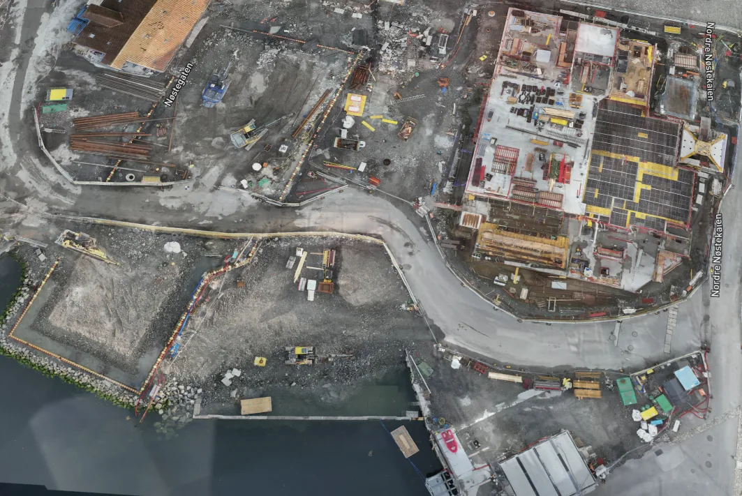
3D models, orthophotos and terrain models from overlapping aerial imagery — for construction documentation, progress reporting, volumetric calculations and BIM integration.
Request a SurveyPhotogrammetry derives accurate 3D geometry from overlapping drone captured imagery — producing orthophotos, terrain models, point clouds and BIM-ready meshes that feed directly into your engineering workflows.
RTK GNSS combined with ground control points produces horizontal accuracy of 1–3 cm and vertical accuracy of 2–5 cm.
Deliverables in industry standard formats (GeoTIFF, LAS, IFC, RVT, FBX) integrate directly with Revit, Navisworks, Plant 3D and GIS workflows.
Often combined with LiDAR in a single mobilisation — photogrammetry adds photo realistic texture to LiDAR's geometric precision.
Operations under EASA Specific Category and BVLOS approval — multi-site campaigns possible without per-flight authorisations.

RTK GNSS plus ground control points achieves construction-grade accuracy across the entire survey area.
Unlike LiDAR-only models, photogrammetry produces fully textured meshes — visually identical to the actual structure.
A 50,000 m² site can be flown in 30-60 minutes; processing returns first orthophoto within 24 hours.
Direct export to RVT, IFC, RCS — no third-party conversion required for your engineering pipeline.
Stockpile, cut/fill and earthworks volumes calculated to ±2-3% — verifiable against survey baseline.
Photogrammetry models form the visual layer of digital twins — combined with LiDAR and IoT data for full asset representation.
Indicative figures based on typical engagements — actuals depend on scope, asset and access constraints.
Photogrammetry serves construction, offshore, civil infrastructure and industrial documentation — anywhere accurate 3D geometry adds value.
Weekly or monthly aerial captures track build progression — orthophotos overlay against design drawings to verify schedule and detect deviation.
Stockpile, aggregate, ore and waste volume calculations for material handling and quarry operations — ±2-3% accuracy verifiable.
Complete 3D as-built records of completed structures, ready for handover, FM and lifecycle management.
Point clouds and meshes imported directly into Autodesk Revit, Navisworks and Plant 3D for clash detection and brownfield design.
Digital terrain and surface models for civil engineering, road design, drainage analysis and site planning.
Single mobilisation captures both — LiDAR for geometric precision, photogrammetry for photo realistic texture and visualisation.
LiDAR uses laser pulses to measure distance directly and works in low light and through vegetation; photogrammetry derives geometry from overlapping photographs and produces photo realistic colour-textured models at lower cost. Many surveys combine both — see our LiDAR & 3D Scanning page.
With RTK GNSS and properly placed ground control points, horizontal accuracy is typically 1–3 cm and vertical 2–5 cm. Higher accuracy is achievable in specific zones with denser GCPs.
Orthomosaic (GeoTIFF), digital surface model (DSM), digital terrain model (DTM), 3D textured mesh (OBJ/FBX/GLB), point cloud (LAS/LAZ/E57), contour lines, and volumetric calculations. Direct export to BIM formats (IFC, RVT, RCS) for your engineering pipeline.
A 50,000 m² site is typically flown in 30-60 minutes on site. Processing for orthophoto and basic 3D model returns within 24 hours; full BIM-ready deliverables within 3-5 working days depending on complexity.
Tell us about your site, accuracy needs and target software pipeline. We'll scope the survey and recommend the right combination of photogrammetry and LiDAR.